


Google Maps sucks | you out of thought

This is part of Disassemble, a philosophy of tech newsletter.

How do you create a map?
You schematize the world. You signify, you symbolise. You leave elements out, while drawing attention to others. On a map, every detail of the territory can't be displayed. If it were, the map would be identical to the very territory it represents, as per Borges excellent story, On Exactitude in Science, which is concise enough that I can repeat here in its entirety:

The 'Art of Cartography' is not fulfilling its role when it presents everything.
Deciding what to include and what not to requires decisions to be made. These decisions have enormous impact as no human has perfect empirical knowledge of geography. No one person has travelled every corner of the planet. We all must trust cartographical representations, and information presented to us, in order to comprehend our world and get around in it.
It's no surprise then that there is enormous power in deciding what gets represented and what doesn't in maps.
In my previous newsletters I discussed the Heideggerian concept of dasein, a way of conceptualising how humans exist in the world: humans are not creatures rationally evaluating objects in their world, instead they are situated in a world that presents itself with possibilities for action. I further noted that digital designers - everyone involved in creating digital objects actually - don't foster the ability for users to question why they act within dasein; designers design for doing, not for asking why this dasein, or how that dasein.
Maps are particularly interesting because they relate to another concept of Heidegger: ‘revealing’.
Heidegger argued that:
Technology in the ontological sense is not just not just the collection of things and activities, but also a mode of truth or a field within which things and activities may appear as they do.
- Don Ihde, Heidegger's Technologies: Postphenomenological Perspectives
Heidegger argued that technology reveals a certain dasein to be correct - certain ways of being are brought forth to be considered ‘proper’. It doesn't mean that these ways of being represent an irrefutable truth, simply that they are actions that are ‘called up’ by particular technologies. In selecting certain details and leaving out others, maps reveal a certain reality to be true, which affects our actions.
There's no clearer example of this than with Google maps.
Let's look at a place near where I live: Brick Lane, in London.
Known for its eclectic, hip atmosphere - everything from a cereal cafe, to a mosque, to an old brewery sit within it - Brick Lane is riddled with character. That character is no more present than in two Beigel (Bagel?) shops that have competed with one another for untold years.
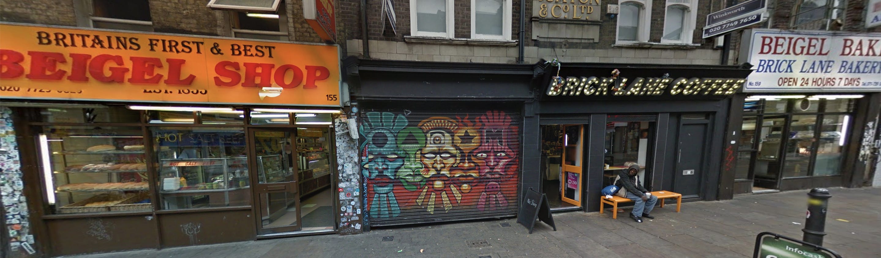
These two shops are visible clearly on Google Street View, nearly right next to each other. Yet looking at Google Maps only one is visible, no matter the zoom level.

Why is this? Who knows.
It's not at all clear to the user why some business are visible yet others are not.
Perhaps this mysterious beigel place was not added to Google Maps? Well, it certainly seems to be if you manually type in its address:

There's no information on why certain business appear on Google Maps but others don't. In fact, one business may appear for one user, but not for another. How and when certain businesses appear are subject to a dance of algorithms and data that we are not privy to. This has massive implications for what we treat as actually existing or not existing, what is relevant or irrelevant.
To place it within the context of the generalised philosophical structure at hand: Google Maps contributes significantly to our information environment - our dasein. A particular part of dasein is revealed, and why it is revealed is not clear. How to change it isn't clear either. We are thrown into this digital-cum-real world without an understanding of its genesis. Yet we act upon this revealed world in specific, ‘correct’ ways.
Let's look at another example in Brick Lane.
Zooming in and out, you'll see that different businesses appear at different times. Why? It's not clear intuitively why this should happen from the user's perspective. And how can I control which types of businesses appear?

You'll notice the Pride of Spitalfields, a well known old pub, appears at a high level. Vegan Yes, a newish cafe, appears at a much lower zoom level. I've spoken to the owner of Vegan Yes and his businesses has been suffering immeasurably under coronavirus. It’s interesting and rather depressing to consider how his presence or non-presence on digital spheres affects his livelihood, yet affecting this presence is difficult or impossible.
The problem is more than Google not representing accurate, schematised versions of territory, they are actively revealing a particular schema that is inscrutable in its creation but clear in its purpose - action, and particular action at that: here is how you spend money in targeted places and thus support our ad model. Action is afforded, not interrogation.
Appearing or not appearing at different zoom levels has massive impacts on businesses, whose proprietors may or not be computer - or even English - literate. The sad thing is these are people aware of how their business are affected, but they can do little about it.

There are thousands (at least) of these posts on the Google Maps business forums.
Interrogating this revealing structure with dasein is nigh on impossible. The manufactured dasein of Google maps is large and impervious, presenting a holistic whole to the user in the name of good user experience, but in the end making it difficult to fathom. The seamless whole leaves little room to get a foothold.
Even writing this post has been difficult because it's tremendously hard to find out why certain businesses, landmarks and locations appear at certain zoom levels, or indeed, at all, even for someone who spends their life on a computer. Google itself remains devoid of help - it merely presents you with others that have the same question.

So this revealed part of dasein isn't just Google maps, but the entire information environment that goes into maintaining and designing this whole (hole…). Again, the goal isn't to question or understand it, but to use it, to act within in. The larger and more comprehensive Google can make their dasein, the more illegible it becomes. A thorough act of revealing fades into a background by being ubiquitous.
It might be argued that if criteria for salience on Google Maps were legible, it would be abused. But this is a specious conclusion. Look at Open Street Map.

Open Street Map manages to engender equal footing for business by displaying all icons, all businesses at relevant zoom levels. The flattening of hierarchy disempowers the creator of the map of their opaque revealing mechanism. Open Street Map, unlike Google, is a not-for-profit organisation so their affordance structure isn’t necessarily just about action - that is, buying.
Instead, the 'revealing' nature of Open Street Map provides a dasein that is immediately scrutable. Editing the data is simple as well.

Is Open Street Maps showing 'everything;' here, committing the error of Borges' cartographers? No, they are structuring a dasein that allows for investigation. Certainly the usability and even utility of Open Street Maps could be improved - more personalisation would be helpful - but fundamentally it operates with a respect for the reflection and interrogation of dasein.
This is the Art of Cartography.
Philosopher Jean Baudrillard references the Borges poem in his book Simulacra and Simulation:
Henceforth, it is the map that precedes the territory - precession of simulacra - it is the map that engenders the territory and if we were to revive the fable today, it would be the territory whose shreds are slowly rotting across the map.
If what is revealed to us is the procession of simulacra that is Google Maps, over and above the territory, why is Google not designing for the legibility of this simulacra? Why can't we see the threads that make up the map, the rationale behind the cartographers choices? Why is the map telling us to act rather than getting us to ask why to act or how to act?